Rising Seas

Did You Know? Part 5: Preservation & Sustainability

December 14, 2022

Historic barn in Gorham, now boasting solar panels

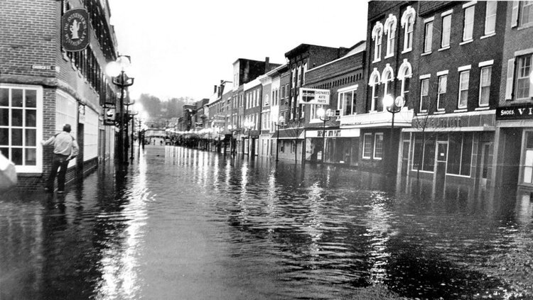
High tide flooding on Commercial Street, photo by Corey Templeton

As an organization that’s been around for nearly 60 years, we are involved in a lot of different things, and we want to make sure you know the full scope of what we do.


The most eco-friendly building is the one already built. New construction takes an immense environmental toll, from demolition and landfill of existing buildings to the short lifespan of new materials and the energy that goes into their manufacture. The National Trust for Historic Preservation has put together this great page of facts about the environmental impact of new construction vs. preservation.
 

What does this mean for our work?

New buildings generate emissions during the construction process. Even the most energy efficient new structures can take as much as 80 years to offset those initial emissions. We encourage adaptive use of structures and ongoing maintenance of existing spaces. Our work to expand historic tax credit programs means that the financial burden is eased for property owners undertaking preservation projects. When a building can't be saved, and we recognize that they can't all last forever, we advocate for its careful deconstruction so that its materials may be repurposed into new construction or to add period-appropriate elements and materials to rehabilitation projects. 

Older properties are often described as inefficient, but they don't need to be! There are so many ways to wake an old home energy efficient through weatherization, much of which can be done simply and affordably as DIY projects. When the need is greater, we are happy to point you in the right direction to trades people and providers who can help with anything from insulation and custom storm windows to the installation of solar panels. We have a whole page of resources on our website and are always happy to answer questions you may have.

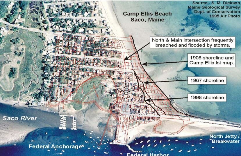
Staying Above Water, a Property Owner's Guide, free, downloadable reference

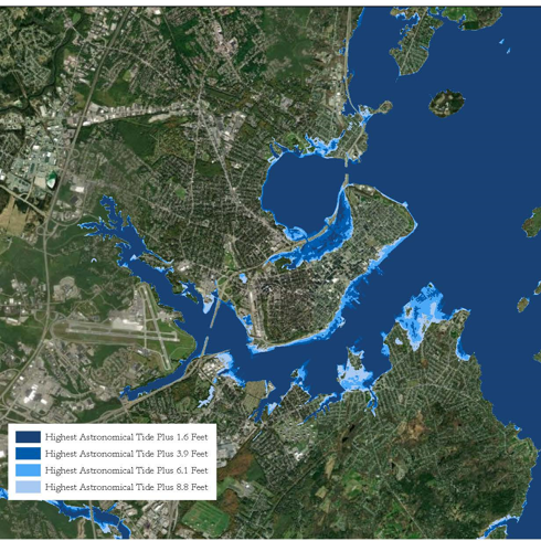
Sea Level Rise scenarios by P. A. Slovinsky, S, Rickerich, and C. H. Halsted of the Maine Geological Survey, as appears in Staying Above Water

Historic Preservation and Rising Waters

Flooding in Gardiner in 1936 Fogler Library, University of Maine

Flooding in Gardiner in 1936 Fogler Library, University of Maine

Downtown Gardiner Floods in 1987 Portland Press Herald

Downtown Gardiner Floods in 1987 Portland Press Herald

Flooding in a watery state like Maine is not unusual. Spring thaw usually brings warnings of flooding along Maine’s rivers and streams. An occasional Nor’Easter that arrives during high tide can mean flooding will wreck havoc on our coastal communities. What can we learn from past events? What can we learn from other coastal communities across the county? What happens to historic buildings that flood periodically? What can be done to alleviate the repeated flooding and damage to properties? As sea levels rise and storm intensity and frequency increase, preservationists are grappling with these issues. What should we do?

Doing Nothing

Doing nothing will likely result in the loss of historic resources. Maine has already experienced loss of coastal structures, notably thirty-eight homes at Saco’s Camp Ellis and the dramatic loss of an industrial building in Lubec.

Despite a fundraising campaign and plans to raise and relocate an endangered waterfront building, Lubec lost the historic landmark in a January 2018 storm that lashed the region with snow, rain and high winds. The storm coincided with an astronomically high tide. Listed on the National Registered of Historic Places, the McCurdy Smokehouse brining shed, was located in the channel east of Water Street and long a part of the Lubec Landmarks collection. It came free of supporting pilings during the peak of the storm‑surge driven tide, turning the shed from a historical structure into a hazard to navigation. After crossing the Lubec Channel into Canada, the shed ended up coming to rest on the Campobello shore, where scavengers dismantled parts of it before Lubec Landmarks and Canadian authorities could act. Thankfully, in its float across the channel it did not collide with the Franklin D. Roosevelt Memorial Bridge. More information on the McCurdy Smokehouse can be found at the Island Institute.

Recognize Loss: let nature takes its course

Rising seas and erosion poses an especially acute problem for managing cultural resources because our resources are unique and irreplaceable — once lost, they are lost forever. If moved or altered, they lose aspects of their significance and meaning. Every year, we lose irreplaceable parts of our collective cultural heritage, sometimes before we even know they exist. Therefore, the decisions we make and the priorities we set today will determine the effectiveness of our stewardship of cultural resources in the coming decades.

Economic or other practicalities may mean some communities will decide that they can’t save all their historic resources, either through relocation or adaptation. What then can be done in the short term to manage those properties? Documenting historic resources is always a good first step, then decisions can be made about short term actions.

“Responsible stewardship requires making choices that promote
resilience and taking sustainable management actions. Funding
temporary repairs for resources that cannot, because of their
location or fragility, be saved for the long term, demands
careful thought. Managers should consider choices such as
documenting some resources and allowing them to fall into
ruin rather than rebuilding after major storms.”
— National Park Service, PM 14-02

The United Kingdom’s National Trust stewards 775 miles of dramatic, diverse and ever-changing coastline around England, Wales and Northern Ireland. With over 700 properties that could be lost due to erosion by 2030 and 247,000 residences and businesses at risk from flooding, in 2005 the organization concluded that they could no longer rely solely on building their way out of trouble on the coast and that coastal ‘defence’ as the only response to managing coastal change looked increasingly less plausible. They established a new policy, Shifting Sands, committing them to working with natural processes and adapting to coastal change – for instance by rolling back, moving buildings and infrastructure out of harm’s way. Their policy sets out goals to:

  • Be driven by long-term sustainable plans, not short-term engineered defenses

  • See coastal adaptation as a positive force for good

  • Take action now – move from saying to doing

  • Work closely with communities – with everyone having their say

  • Act across boundaries – join forces with partners and people

  • Innovate – have the courage to try out new ideas

  • Aspire to a healthy coastline, shaped by natural forces.

Managed Retreat

Managed retreat or managed realignment is a coastal management strategy that allows a shoreline to move inland, instead of attempting to hold the line with engineered defenses. In many cases of managed retreat, buildings and infrastructure are “moved” out of harm’s way and natural areas are restored in the abandoned area. The restored natural coastal habitat provides extra protection or a buffer from flooding. This approach is relatively new but is gaining traction among coastal policy makers and managers in the face of increased coastal hazard risks. There is a growing recognition that attempting to “hold the line” in many communities is a losing battle - and a costly one.

For decades, federal policy has subsidized building in the flood zone via the National Flood Insurance Program (NFIP) of 1968. This facilitates a cycle of destroy-rebuild-repeat within the flood zone. Federal data shows that from 1978 to 2018, more than 36,000 NFIP-insured properties filed repeated claims for flood damage. A 2019 study published in Science Magazine laid out a case for strategic and managed retreat, found that a single home in Mississippi was rebuilt 34 times in 32 years using $663,000 in federal tax dollars—for a home worth only $69,000.

Retreat isn’t a word one normally associated with the U.S. military, but Naval Station Norfolk, because of its strategic importance and its vulnerability to climate change, is at the leading edge of adaptation and managed retreat discussions in the country. Naval Station Norfolk is a vast complex in southeastern Virginia whose 80,000 active-duty personnel make it the largest naval base on earth by population. The ships and aircraft stationed at Naval Station Norfolk are at risk as the seas are rising, and the soil is sinking. Already, key access roads to the low-lying Naval Station Norfolk are occasionally submerged during high tides. Current and former Navy leaders have been outspoken on the need to adapt to the increased numbers of days that they experience recurrent flooding and the critical need to make plans for what the Navy will do if Norfolk goes underwater. While headway has been made, planned critical safety upgrades at the naval station were halted and funds redirected by the previous administration.

Back in 2014, the federal government launched the Hampton Roads Sea Level Rise Preparedness and Resilience Intergovernmental Pilot Project (IPP). Its purpose was to bring together civilian and military officials to plan for a future of rising water and worsening floods. For the next two years, city leaders and state planners, Air Force colonels and Navy commanders worked across their own jurisdictional boundaries. They examined how rising sea levels could endanger roads, bridges, schools, businesses, and public health. Despite challenges, it helped change the conversation in the community. In 2019 the Navy and the cities of Norfolk and Virginia Beach released a joint report that looked at steps needed to protect schools, roads, a hospital, and Naval Station Norfolk from the encroaching water. Now Norfolk and Virginia Beach are taking steps to plan and execute relocation of residents in harms way.


Portland’s waterfront and the Bayside neighborhood are already experiencing recurrent flooding and are predicted to increasingly be impacted by the effects of sea level rise. Natural Resource Council of Maine

Portland’s waterfront and the Bayside neighborhood are already experiencing recurrent flooding and are predicted to increasingly be impacted by the effects of sea level rise. Natural Resource Council of Maine

As Greater Portland begins to plan how to address the impacts of climate change and preservationists assist in those conversations, hopefully we will look at the work being done in other communities here in the United States and abroad that are leading the way in mitigation and adaptation actions that will help to conserve our collective cultural heritage.

Landmarks has been studying the risks to historic properties in Greater Portland and documenting properties that may be impacted by recurrent flooding and sea level rise. We have compiled a guide for property owners to help them begin to think about their property’s risks and potential ways to adapt or mitigate the potential impacts of climate change. You can check out our new publication on our website!


What’s Happening in Preservation at the State and National Level?

by Julie Ann Larry, Director of Advocacy

I hope that everyone is well this holiday season. I took a bit of a break over the Thanksgiving holiday away from the internet and phone service. It was much needed time off but now I am back at work and ready to engage in all the exciting new projects and policies that are in the works for 2021!

While Greater Portland Landmarks works mostly at the local level, we also engage with state and federal legislation that will impact the historic preservation profession and our historic communities. While I was away there were several developments at the state and federal level.

In Maine this week was the release of the Governor’s Climate Action Plan. Greater Portland Landmarks and our preservation allies participated in the public workshops held by the Climate Council this spring and summer. Learn more about our advocacy on the Climate Action Plan and read our joint letter to the Council here. The plan’s goal is to ensure that Maine’s communities, industries, and people are resilient to the impacts of climate change and to reduce Maine’s Carbon Emissions 45% below 1990 levels by 2030. The plan has many important steps, but of special note are plans to help improve the efficiency of Maine’s existing housing stock.

Historic resources in Maine’s coastal and riverine communities are at risk from the impacts of climate change. Maine’s Climate Action Plan sets goals to reduce the state’s carbon emissions and make our communities more resilient.

Historic resources in Maine’s coastal and riverine communities are at risk from the impacts of climate change. Maine’s Climate Action Plan sets goals to reduce the state’s carbon emissions and make our communities more resilient.

One significant step will be to switch buildings to cleaner heating and cooling systems. About 60% of Maine households rely on heating oil as their primary home heating source — the highest percentage in the country. The plan calls for the installation of at least 100,000 new heat pumps in Maine by 2025. Did you know Greater Portland Landmarks’ headquarters, the Safford House, is heated by water-cooled, ducted heat pumps? Our system was installed nearly a decade ago, replacing an old oil-fired furnace.

If you are interested in the best practices you should follow when making your older home more energy efficient, check out Landmarks’ publication The Energy Efficient Old House. We also have other publications on sustainability and energy efficiency on our Resources webpage. Greater Portland Landmarks believes historic preservation and the green building movement are natural allies: the greenest building, as the saying goes, is the one that is already built! Greater Portland’s existing older buildings embody a heavy prior investment in resources and energy. Keeping them in use conserves that investment, and is recycling at its best!

As the Congress looks ahead to 2021, preservationists are advocating for legislation that will improve opportunities for affordable housing in historic buildings and address the vulnerability of our communities to the impacts of climate change.

As the Congress looks ahead to 2021, preservationists are advocating for legislation that will improve opportunities for affordable housing in historic buildings and address the vulnerability of our communities to the impacts of climate change.

The Motherhouse on Stevens Avenue in Portland is one of several projects in Maine that has been rehabilitated pairing Low-Income Housing Tax Credits and Historic Tax Credits. We are joining preservation advocates nationwide to make this paired fundi…

The Motherhouse on Stevens Avenue in Portland is one of several projects in Maine that has been rehabilitated pairing Low-Income Housing Tax Credits and Historic Tax Credits. We are joining preservation advocates nationwide to make this paired funding process easier to increase affordable housing opportunities in our community.

At the federal level several issues remain under negotiation while the current Congress debates its final bills during the Lame-Duck session this month, or face uncertain futures as the new Biden administration takes shape. Last month Tom Cassidy, Vice President for Government Relations at the National Trust for Historic Preservation led a presentation to preservation advocates across the nation on the most pressing policy issues facing the preservation community in the months ahead. Potential areas of focus for the last days of the 116th Congress will likely be pandemic relief and extending government funding beyond next week’s December 11th deadline. Preservationist are presently advocating for improvements to the Historic Tax Credit (HTCs) that will aid in the pairing of Low-Income Housing Tax Credit (LIHTC) and the HTCs. The pairing of these two programs has benefited a number of affordable housing projects in Maine, including the rehabilitation of the Motherhouse on Stevens Avenue in Portland and the Southgate Mansion in Scarborough. In addition, preservationists are advocating for increased opportunities for small projects to take advantage of HTCs.

Landmarks is working to document and conserve coastal resources impacted by climate change.

Landmarks is working to document and conserve coastal resources impacted by climate change.

The National Trust’s presentation also looked forward to likely priorities of the 117th Congress: Climate Change, Affordable Housing, and Racial Equity. Landmarks, like many historic preservation non-profits across the nation, has expanded its focus to address challenges in all three areas in recent years. We plan to continue to broaden our advocacy and education programming to reflect our ongoing research in these areas. If you missed our Staying Above Water presentations in October, I hope you’ll take some time to check out the fantastic speakers that joined us to discuss the reasons Maine is susceptible to the impacts of climate change, what those impacts might be, and how we can improve our resilience.

With your support, through donations and your individual advocacy, we are successfully able to advocate for the reuse of historic buildings to the benefit of the environment and our neighbors. Your support also allows us to advocate for sound policies at the local, state and national level that protect and enhance our important cultural resources. Thank you for supporting Greater Portland Landmarks this year!

Maine Midden Minders

By Kate Burch

Photo via Maine Midden Minders

Photo via Maine Midden Minders

Middens record the history of Maine’s first inhabitants, providing evidence of ancient lives and environments from 5,000 years ago until the time of European settlement.  Largely composed of shells and animal remains, along with seeds, stone tools, and pieces of pottery, middens have often been referred to as “ancient trash heaps”, but archaeologists now recognize that they represent more than just waste disposal. Maine’s middens are some of our most at-risk heritage sites due to climate change, as sea level rise hastens the rate of coastal erosion.

At the University of Maine, the Midden Minders project is using volunteer citizen scientists to document these important sites and monitor their condition and erosion. Dr. Alice Kelley and Dr. Bonnie Newsom, who lead the project, shared more information with Greater Portland Landmarks about Midden Minders and the risks facing middens.

GPL: How many known sites remain undocumented, and what would it take to document them?

Shell midden with meter measuring stick for scale (Photo via Maine Midden Minders)

Shell midden with meter measuring stick for scale (Photo via Maine Midden Minders)

Kelley and Newsom: According to Dr. Arthur Spiess, Maine State Archaeologist, there are approx. 2000 documented shell midden sites on Maine’s islands and mainland coastline.  These sites have been identified, but are at varying levels of analysis and reporting.  We don’t know how many sites remain undocumented, but do know that new sites are discovered every year, while other sites are lost to erosion or development or damaged by looting.  A coast-wide survey of the Maine coasts and islands would be required to locate, examine and document all of Maine’s known shell middens.  This would be a challenging (and expensive) task.

Currently, members of the public or conservation organizations are welcome to report the locations of shell middens to the Midden Minders (middenminders@maine.edu).  We will see that the information is forwarded to the appropriate federal, state, or tribal agency for documentation.

GPL: What types of sites are most at risk, and what can be done to preserve them?

Kelley and Newsom:  Sites that are located directly on the shoreline, either on a beach or a bluff, are the most at risk.  Climate change-related sea level rise, increasing storm intensity and frequency, and more periods of winter freeze-thaw activity are increasing shoreline erosion. As bluffs and beaches along the coast erode, shell middens collapse and are lost to the sea.

Preserving shell middens is not possible, but the cultural and environmental information they contain can be preserved.  This is what the Midden Minders and archaeology field schools in collaborations with conservation and professional and tribal organizations are working to do.

The Midden Minders project seeks to monitor and document the erosion of shell middens using a variety of measurement techniques and photography (see maine.edu/middenminders).  Conservation and tribal organizations are working to collaborate with the Midden Minders to document change and preserve information and protect shell middens from looting, erosion, and development.

GPL: What information and cultural heritage is at risk of being lost if we lose these sites?

Kelley and Newsom:  Thousands of years of indigenous history and lifeways are archived in shell middens. This important part of Maine’s history is being lost to the sea as these sites disappear.  In the past, the cultural history of indigenous people living as coastal hunters, fishers and gatherers has been largely marginalized and discounted, while colonial and historic structures are awarded attention and preservation funding. The middens’ record of thousands of years of sustainable use of the coast and adaptation to change may be relevant to today’s climate change issues.  The knowledge contained in shell middens also provides an opportunity for contemporary tribal communities to reconnect with a disrupted past and strengthen tribal communities.

Additionally, shell middens contain a record of the past environments when they were formed.  The faunal and floral remains in the middens are a record of conditions at that time.  Shell middens are an archive of extinct species, such as great auk and sea mink, that are not preserved elsewhere.  This material is one of the very few archives of coastal conditions thousands of years ago.

GPL: What is the history of efforts to preserve midden sites in Maine?

A 19th century investor in a project to turn middens into chicken feed surveys a midden in Maine.

A 19th century investor in a project to turn middens into chicken feed surveys a midden in Maine.

Kelley and Newsom:  In the past, shell middens were viewed as a resource to use or a source of artifacts for amusement and display.  Considered trash heaps, the shells were mined to provide lime or ground up for chicken feed.  Early archaeologists viewed the middens as a source of interesting animal bones and artifacts.  Currently, archaeologists value the middens as an archive of past lifeways and environments and local tribal people value them as part of their ancestral heritage.  Excavations carefully record details about the site, landscape, artifacts, materials, and stratigraphy, in such a way that the site can be reconstructed digitally and archaeological and environmental information is preserved.  House floors, activity areas, and firepits can be recognized through careful excavation. Additionally, archaeologists at modern excavations work closely with descendant communities on data recovery, preservation and interpretation as a way to connect past and present peoples.

However, archaeological excavations are expensive in time and funding.  As a result, only a few middens are carefully excavated each year.  The Midden Minders program seeks to support the preservation of midden information by monitoring and documenting shell midden erosion along Maine’s coast.  In this effort, volunteer citizen scientists use simple tools to measure erosion and photography to document change and artifacts.  The information gathered will be used by cultural resource managers and researchers to make informed decisions about excavations and help understand the impact of climate change on cultural heritage.

To learn more and volunteer, visit the Maine Midden Minders website!

Portland's Changing Waterfront

An image of the Portland waterfront c1900. Image from the Maine Historical Society’s Maine Memory MMN#13916

An image of the Portland waterfront c1900. Image from the Maine Historical Society’s Maine Memory MMN#13916

is our historic waterfront at Risk?

Portland’s central waterfront extends along the south side of Commercial Street, from Deake’s Wharf in the west to Maine Wharf in the east. This central zone has been a significant economic and cultural asset for over 350 years. It is the largest resource for commercial vessel berthing in Portland Harbor, sitting between the western waterfront (featuring deep sea berthing and dedicated to freight and industrial uses) and the eastern waterfront (a transportation hub with facilities for cruise ships and ferries). The central waterfront is the heart of our tourism industry as well as the core of the city’s working waterfront.

Figure 1. Portland’s waterfront in 1776. Courtesy of Rosemary Mosher and Osher Map Library.

Figure 1. Portland’s waterfront in 1776. Courtesy of Rosemary Mosher and Osher Map Library.

Figure 2. NOAA’s projected inundation map of Portland with a ten-foot surge.

Figure 2. NOAA’s projected inundation map of Portland with a ten-foot surge.

The central waterfront we know today is filled land, built to facilitate a railroad connection between the east and west ends of the city. This makes the area particularly vulnerable to increased storm surges, high tide events, and projected sea level rise. Modern flood and storm surge projections show the extent of possible flood waters mirrors the known historical shape of the peninsula. A composite map showing the peninsula’s coastline in 1776 versus today (Figure 1) is closely replicated by NOAA’s Sea Level Rise Viewer when predicting a ten-foot surge in sea level (Figure 2). NOAA classifies the entire central waterfront as “highly vulnerable”.

Figure 3. Tidal flooding on Portland Pier has been occurring for many years.

Figure 3. Tidal flooding on Portland Pier has been occurring for many years.

A 2013 Flooding Vulnerability Assessment for the Commercial Street waterfront area predicted the cumulative expected storm damage to the value of all buildings and improvements between 2013 and 2050 to reach $32.9 million. According to that assessment, in 2050, buildings on every wharf from the Portland Fish Pier to the Maine State Pier are vulnerable to significant damage. Buildings on Widgery Wharf and Portland Pier, two of the Central Waterfront’s most historic wharves, are at risk of being permanently inundated due to sea level rise by 2050. Portland Pier (which has some of the Central Waterfront’s most historic structures), has historically been particularly prone to flooding (Figure 3).

Early History of Central Waterfront - Infilling and the Creation of COMMERCIAL Street

Figure 4. From a 1826 manuscript map titled Portland with a view of the different streets by Lemuel Moody (1767-1846) features the city streets and designations, as well as buildings, wharves and rope walks. Portland wharves extend from Fore Street,…

Figure 4. From a 1826 manuscript map titled Portland with a view of the different streets by Lemuel Moody (1767-1846) features the city streets and designations, as well as buildings, wharves and rope walks. Portland wharves extend from Fore Street, then the shore line along the central waterfront.

By the end of the eighteenth century, Portland was a booming center of trade, supported by its lumber trade and fisheries as well as the rise of the molasses trade. Trade with the West Indies became quite lucrative for Portland, who exported a wide array of wood products in exchange for the sweetening agent. Molasses was a common dietary staple and used in rum production.

The area around today’s central waterfront was a bustling commercial and cultural center. Merchants and tradesmen relied on the sea to ship and trade cotton, flour, salt, fish, tobacco, wine, rye, glass, and lumber in several forms. Store owners, shipbuilders, blockmakers, silversmiths, blacksmiths, and distillers operated on the waterfront. At the time, the wharves that had sprung up following the Revolution were breastworks, or rudimentary docks made of piled lumber, rubble, and stones. A more substantial, permanent wharf was required to accommodate traffic coming in and out of the harbor.

In 1793, a group of 25 sea captains and merchants formed a group, calling themselves the “Proprietors of Union Wharf.” They set out to build an appropriate structure on a breastworks that sat at the foot of Union Street. The resulting wharf had no comparison in the harbor. The 110-foot wide structure sat upon a base of rocks, dirt, and other fill material, which supported massive oak pilings covered with wooden planks. Over 3,500 tons of lumber was used to construct the wharf, which boasted a 48-foot-wide passageway through its center. The wharf was promptly populated with ten or so businesses. Other wharves quickly took form and by 1806 Portland had emerged as the sixth largest seaport in the country.

Figure 5. Portland Public Works overlay maps circa 2001 depict the evolution of the Portland waterfront. The blue lines depict the original shoreline close to Fore Street.

Figure 5. Portland Public Works overlay maps circa 2001 depict the evolution of the Portland waterfront. The blue lines depict the original shoreline close to Fore Street.

The mid-eighteenth century and the rise of railroads brought about the most dramatic physical transformation of the waterfront’s history. Access to Canadian ports was limited during the winter months due to the St. Lawrence River freezing over. In an attempt to lure Canadian trade to Portland, Board of Trade leader John A. Poor spearheaded the effort to extend Canada’s Grand Trunk Railway from Montreal to Portland. Poor espoused Portland Harbor’s natural advantages and the half-day of travel time that could be saved by choosing it over Boston or New York. The Atlantic & St. Lawrence Railroad, later taken over by the Grand Trunk, brought car loads of grain to Portland from Canada and the West for reshipment.

In order to link the Canadian Grand Trunk Railway to the Portland, Saco & Portsmouth Railroad terminal at the foot of High Street and Portland’s wharves, city’s leaders agreed to build a new road with tracks down its center running perpendicular to the waterfront’s docks. Completed in 1853 for $80,000, Commercial Street was 100 feet wide and nearly a mile long, and was constructed on filled land in the harbor east of Fore Street (which originally followed the shoreline). The road was constructed through the middle of existing wharves, and obscured smaller wharves completely (Figure 6). As a result, businesses that were once dockside now had a new street between them and the water, and other lots were lost completely. Wharves lost hundreds of feet of berthing space and building space.

Figure 6. An 1852 map of Portland shows the construction of Commercial Street on the Waterfront before the land between Fore and Commercial Streets was completely filled in.

Figure 6. An 1852 map of Portland shows the construction of Commercial Street on the Waterfront before the land between Fore and Commercial Streets was completely filled in.

Figure 7. On an 1858 Map of Portland, just five years after the completion of Commercial Street, five wharves (Union, Dana’s (Merrill’s), Brown’s, Smith’s, and Berlin Mills) had built connecting tracks to take advantage of increased trade opportunit…

Figure 7. On an 1858 Map of Portland, just five years after the completion of Commercial Street, five wharves (Union, Dana’s (Merrill’s), Brown’s, Smith’s, and Berlin Mills) had built connecting tracks to take advantage of increased trade opportunities.

On new or extended wharves, businesses quickly took advantage of the presence of the new railroad along the waterfront. Within five years of Commercial Street’s completion, connecting tracks were built down the lengths of several wharves (Figure 7). Canada’s grain was exported from the port, while lumber, shipbuilding, molasses, and fish remained important industries.

The wharves on the central waterfront were all constructed as working piers (as opposed to pleasure piers), specifically intended for the docking, loading, and unloading of vessels. The area’s wharves are largely fill supported, often with wood pylons supporting the apron (outer edge) and terminating end, farthest from Commercial Street. Wharf builders obviously made use of Maine’s abundant supply of granite and pine during their construction. Structures on the wharves vary drastically in scale from 100,000 square-foot masonry factories to 8-by-10-foot wood-frame fish houses. From early images we know that many wharves were paved with granite paving blocks.

The 20th Century - A crumbling waterfront

Portland’s waterfront at the turn of the century was populated by ferry terminals, steamship docks, lumber yards, coal companies, cooperages, and cold storage facilities.

Figure 8. Portland Cold Storage Co. circa 1905.

Figure 8. Portland Cold Storage Co. circa 1905.

Portland Cold Storage Co. was located at 188 Commercial Street on Central (now Chandler's) Wharf. Founded in 1905, the cold-storage firm was managed by James C. Poole (1845-1924) of Boothbay Harbor (Figure 8, pictured standing at left). In 1915, Poole formed another cold storage company on Union Wharf. Train tracks allowed rail cars to be loaded and unloaded right outside the storage building.

Figure 9. A 1900 advertisement for Berlin Mills Co lumber yard and planing mills. Upper right is now Gowen Marine/Portland Yacht Services (Becky's Diner would be to the left of the image). Image to lower right is at the north corner of High and Comm…

Figure 9. A 1900 advertisement for Berlin Mills Co lumber yard and planing mills. Upper right is now Gowen Marine/Portland Yacht Services (Becky's Diner would be to the left of the image). Image to lower right is at the north corner of High and Commercial Streets, now the Rufus Deering Lumber/Hobson’s Landing development.

On the western end of the central waterfront was a large lumber yard, the Berlin Mills Company. In 1851 the St. Lawrence & Atlantic Railroad, later changing its name to Grand Trunk Railway, entered Berlin, New Hampshire. The chance to build a saw mill in Berlin came in 1852 when a group of Portland, Maine businessmen, John B. Brown, Josiah S. Little, Nathan Winslow and Hezekiah Winslow, recognized that the construction of the railroad line through Berlin was a great way to import and export wood products in and out of town. Acquiring water, timber and rail rights, they formed a partnership under the name H. Winslow & Company, which changed its name to Berlin Mills Company in 1868. In Portland the company had a planing mill and wharf for shipping lumber.

In 1889 the Canadian Pacific Railway opened a rail line across the state of Maine from Montreal to Saint John, New Brunswick, transferring the majority of Canada’s transatlantic passenger and cargo shipping to the Saint John during the winter months. This resulted in a loss of Canadian trade revenue in Portland, and Portland lost its standing as a leading regional seaport. The Great Depression in the 1930s caused additional hardship on Portland’s waterfront.

World War II briefly gave the city and its waterfront an economic boost. Portland Harbor became the base of the entire North Atlantic fleet, complete with 30,000 shipyard workers and anchorages filled with Naval destroyers and support vessels. Waterfront merchants profited from the presence of shipyard workers and sailors on leave. However the economic boom of the war years quickly dissipated when military activities ended.

A 1961 Portland Press Herald series, “Our Crumbling Waterfront,” painted a stark picture of the port, describing rotting pylons, empty buildings, and an economic slump. A focus on downtown redevelopment in the Urban Renewal period of the ‘60s and ‘70s, left no little to no funds to devote to the waterfront. A 1978 National Science Foundation study described Portland’s waterfront as one of the most decrepit on the east coast. The following year, voters and public officials were sympathetic to the waterfront’s plight and approved a $9 million bond to help pay for fish piers in Portland.

Spurred by the completion of the Portland Fish Pier in 1983, new construction projects replaced deteriorating piers and rotting pilings across the waterfront. Condominium construction on Chandler’s Wharf in 1985 and at 40 Portland Pier in 1987 as well as other development proposals led to a 1987 moratorium on all development along the waterfront that was non-marine related. The moratorium was overwhelming approved by Portland voters who wanted to protect the working waterfront from non-marine uses. Since the mid 1980s, the city has been challenged to balance protecting fishing and other maritime industries while also promoting a flexible and varied waterfront for non-marine businesses and development.

Will the waterfront’s future look like its past?

Corey Waterfont.jpg

A 2018 inventory of the waterfront observed that the central waterfront remains a center for marine industry, but continues to evolve as permitted under current land use policies. According to the City’s Comprehensive Plan Portland 2030, there has been significant contraction of the waterfront economy and the ground fishing industry on the central waterfront since the 1990s. Ground fishing vessels have diminished by 50% and there has been a 2/3 reduction in landings at the Portland Fish Exchange. The area has also experienced decreasing water depth at the piers due to natural deposition of sediments, which are exacerbated by storm water overflows into the harbor, requiring maintenance dredging to ensure quality commercial berthing opportunities.

Additional planning initiatives for the central waterfront in the City’s comprehensive plan include: investing in pier infrastructure, and exploring funding for pier maintenance; promoting access to the waterfront for commercial and marine activity, including berthing; supporting traditional and emerging marine industries, requiring collaboration with private pier and waterfront property owners to implement policies that promote and protect the marine economy; and planning for climate change.

If the prediction maps are correct, sea level rise needs to be part of the conversation about the future of development along Commercial Street and on the waterfront. Its historic buildings, infrastructure, and its uses, that are so integral to our city’s character and economy are in danger. Public and private leadership, like that which led to the creation of Commercial Street, is necessary to develop comprehensive planning strategies that will guide owners as they assess the risk to their waterfront assets and to direct investments into more resilient infrastructure. Part of the solution will also need the City’s technical standards and land use code to allow for adaptive construction techniques, storm water infrastructure and utilities, site protection, and floodproofing.

At Landmarks we are focused on collaboration and broad public engagement initiatives with other organizations working to raise awareness of the issue as well as developing proactive and sustainable solutions. You can learn more about our work on our website or take a short virtual tour of the waterfront. Stay tuned for upcoming events this summer that will celebrate the history of our waterfront and how historic preservation and the conservation of existing resources are key to developing a strategy of resiliency, risk management and adaptation which will guide changes on the waterfront in the future.

This fall, Greater Portland Landmarks will host a series of panel discussions about the unprecedented challenges to Maine’s cultural and natural heritage due to our changing climate. Bringing together organizations and community leaders, Staying Above Water will highlight the impact climate change is already having on historic buildings and discuss strategies for future adaptation. Landmarks will publish a booklet of case studies later this summer that explore the impacts of a changing climate on a variety of local building types and suggest mitigation strategies for property owners. We hope you will join us!


by Julie Ann Larry, from research compiled by Tova Mellen in 2019.